 | What do you mean you didn''t know there was a river in Los Angeles? Why not take the Target Science Los Angeles River Virtual Tour and see for yourself? Like modern-day Lewis and Clark explorers, you will be able to digitally navigate the river from the headwaters in the San Fernando Valley to the mouth of river in Long Beach, over 50 miles away. |
|
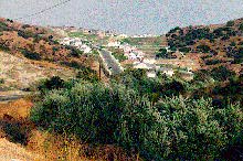
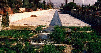
Urban river system in L.A. |
The San Fernando Valley is surrounded by steep mountains and hills. As a result, winter rains speed quickly down these slopes and have very little time to seep into the ground. These mountains border a watershed for the Los Angeles River that covers over 800 square miles |
This small stream in the western hills of the valley is an example of the very beginnings of the river. This water flows near a gated subdivision. If this water does not seep into the ground within half a mile, it will flow into its first concrete channel and on towards the L.A. River |
|
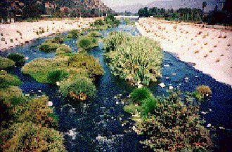
Reclaimed water enters the Los Angeles River in the Sepulveda Basin. The Department of Water and Power releases as much as 75 million gallons of water daily from the Donald C. Tillman Water Reclamation Plant in the basin. In effect, the Los Angeles River now has a year-round supply of water. Normally the summer and fall would be dry. As a result, plant and animal life have begun to thrive downstream |
This is a wonderful place to study birds and plants. The City of Los Angeles has set aside the Sepulveda Basin Wildlife Area to protect native plants and animals. Over 200 species of birds have been seen in the basin. Many birds, attracted by the water, gather here in the fall and winter |
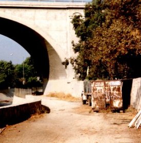
The Arroyo Seco drains a watershed that covers the southwestern section of the San Gabriel Mountains, just northeast of Los Angeles. Many sections of the Arroyo through Pasadena are not channelized. These additional waters increase the demand on the carrying capacity of the Los Angeles River. Here the last few hundred feet of the now concrete arroyo as it ends its journey |
|
It''s OK for the urban river |
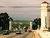
Downtown. Now the bridges that cross the river here preserve some of the architecture and flavor of Los Angeles in the 1920s and 30s, in contrast to the nearby ultra-modern downtown office buildings. |
|
http://www.lalc.k12.ca.us/target/units/river/tour/
http://www.nationalgeographic.com
The first written description of the Los Angeles River is offered by Juan Crespi on the Portola expedition in 1769
There are stopping points along the Los Angeles river: Headwaters, First Channel, Convergence, Sepulveda Basin, Verdugo Wash, Los Feliz, Frogtown, Arroyo Seco fork, 4th Street Bridge, Rio Hondo fork, Lower river, and mouth of the river in Long Beach.
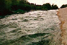
The Los Angeles River does not fit our image of a typical river in a more temperate climate. Rivers in arid climates tend to be seasonal, with little or no flow through much of the year, and heavy flows and flooding through the rainy season. Likewise, the Los Angeles River has two faces. Through the dry season from June to October the river has little or no natural flow. The rainy season in this area''s Mediterranean climate is from November to May, and in these months floods along the river have caused more property damage and deaths than earthquakes. Possibly we can get a glimpse of what the river might have been like by looking at the Santa Clara River, which is one of the only remaining large, relatively natural rivers in the region
The Sepulveda dam controls flooding. Located near the intersection of the 101 and 405 Freeways, The dam and basin controls winter flood waters and alows trapped runoff to seep into the water table. Throughout most of the year the basin is used for recreation. Much of it is recreational parkland. A small lake has been created and the California Native Plant Society is reintroducing native species along the shores.
The Verdugo Wash drains the hills just north of Burbank and Glendale. Here the intersection of the 5 and the 134 Freeways marks the convergence of the Verdugo and the Los Angeles River. The waters from the San Gabriel Mountains and the San Fernando Mountains mix under the 134 overpass. A bike path has recently been opened along this section of the river
The concrete floor gives way to sand and gravel on the section of the river between the Verdugo Wash convergence and Los Feliz. This area of the river hugs the eastern edge of Griffith Park. The park land was donated to Los Angeles one hundred years ago by Col. Griffith J. Griffith with the intention that over five miles of riverfront property would become a grand riverfront park for the city. Col. Griffith, who had made his fortune in mining consulting and real estate in Los Angeles, felt the city needed a great municipal park like the ones he had seen in European cities
The sand and gravel river bed is at the same level of the water table. The river and Griffith Park are now seperated by the Interstate 5 Freeway along this section. The only foot bridge to the river is about one mile south near Los Feliz
Frogtown - this area got its name from the many frogs who used to live here. However most of the frogs (actually Western toads) are gone now. But considering that this location is in the middle of the Los Angeles "rust belt", there is still plenty of wildlife here. According to Kimball Garrett fo the Los Angeles County Museum, over 125 species of birds have been sighted here. This is the southern boundary fo the sandy bottom section that began near Griffith Park. The 5 Freeway crosses the river again at this point and the bottom becomes concrete once more. This area is also known as Taylor Yard. The defunct Southern Pacific railyard now houses a Metro rail facility. During a winter storm most of these plants are completely covered in water
After a journey of over 50 miles, the river waters pass the Queen Mary in Long Beach and drain into the Pacific Ocean. Several times throughout history the river has changed course during a flood and emptied to the west through what is now Marina Del Rey. The flood control channel now fixes Long Beach as the permanent destination for the river.